
 Image 1 of 1
The Most Enduring Nineteenth-Century Map of Manhattan
A Landmark in American Cartography.
One of the scarcest and most important maps of Manhattan ever produced.
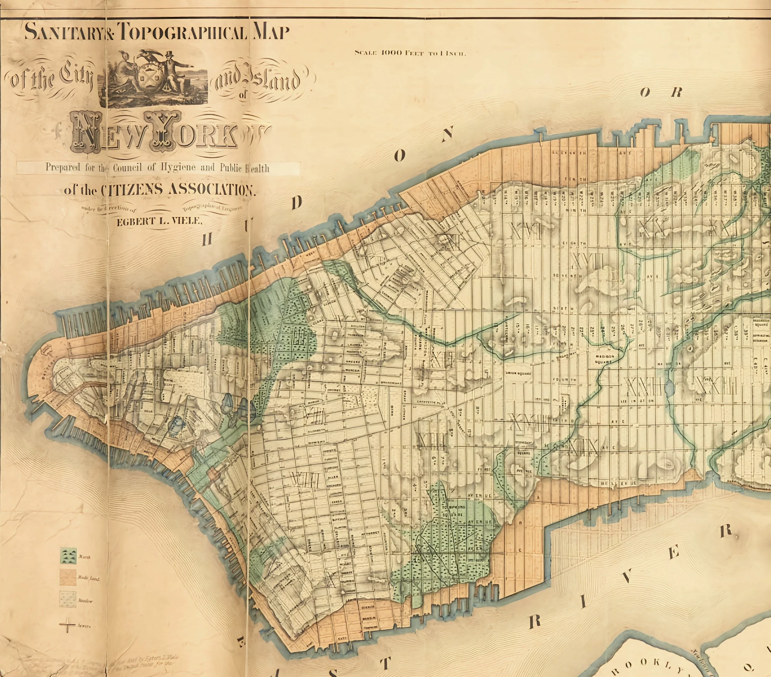
New York: Egbert L. Viele, 1865. This state with the printed paper slip pasted down to the title correcting an error, originally issued accompanying the "Report of the Council of Hygiene and Public Health of the Citizen's Association of New York upon the Sanitary Condition of the City," New York: D. Appleton & Co., 1865 (per Stokes, Iconography of Manhattan Island, Vol. III, p. 778). Measures 19 1/4 x 64 1/4 inches (48.75 x 163 cm); hand-colored lithographed map on two sheets joined, linen-backed with a pink cloth border.
One of the most remarkable maps ever produced of Manhattan: a large-scale (1000 feet=1 inch) work providing a virtual cartographic x-ray of Manhattan Island, recreating on paper its pre-development topography, contours, and hydrology. “It delineates the original watercourses, streams (underground and surface), meadows, marshes, ponds, ditches, canals, and the shoreline before landfill expanded the city’s boundaries” (Augustyn/ Cohen). So accurate was the map in achieving its purpose that it is used to this day by construction companies and public utilities to ascertain where water might still be flowing underground. Martin Febesh (cited in Augustyn/ Cohen), whose company laid the foundation of the Citicorp Centre, said of the map that he had found it “…accurate within feet.” Finally, in 1874, he enlarged the map with corrections, changes and additions, and published it separately... Twenty years of surveying and studying went into perfecting this great map..." (Paul E. Cohen and Robert T. Augustyn, Manhattan in Maps, New York, 1997, pp.136-139).
The current map is an expansion on Viele's first sanitation map of the city, which was published in 1859 and showed only the lower half of the island. In this 1865 edition, issued to accompany his Report of the Council of Hygiene and Public Health of the Citizen's Association of New York upon the Sanitary Condition of the City, Viele maps the whole island for the first time. This map clearly delineates the city's underground rivers, ponds, canals, marshland, meadows, and sewers, as well as infilled shorelines. Viele's work on underground waterways and sanitation came at a time of great concern over disease in the city, namely cholera and malaria, which he believed were caused by an excess of moisture in the ground. He proposed that all sewage and drainage should follow the island's natural waterways, and that "the original water courses should again be permitted to have their deep and free outlets to tide water" (Manhattan in Maps). Despite Viele's intentions for his map, it found both unforeseen longevity and unrelated usefulness in the decades that followed. Its accuracy in mapping the city's waterways made it an invaluable resource to the architects, engineers, and builders constructing a rapidly growing city throughout the twentieth century. For example, it was referenced during the building of the Empire State Building, Stuyvesant Town, and United Nations Plaza.
This is one of the most desirable maps of New York City and is scarce in any condition.
A Landmark in American Cartography.
One of the scarcest and most important maps of Manhattan ever produced.
New York: Egbert L. Viele, 1865. This state with the printed paper slip pasted down to the title correcting an error, originally issued accompanying the "Report of the Council of Hygiene and Public Health of the Citizen's Association of New York upon the Sanitary Condition of the City," New York: D. Appleton & Co., 1865 (per Stokes, Iconography of Manhattan Island, Vol. III, p. 778). Measures 19 1/4 x 64 1/4 inches (48.75 x 163 cm); hand-colored lithographed map on two sheets joined, linen-backed with a pink cloth border.
One of the most remarkable maps ever produced of Manhattan: a large-scale (1000 feet=1 inch) work providing a virtual cartographic x-ray of Manhattan Island, recreating on paper its pre-development topography, contours, and hydrology. “It delineates the original watercourses, streams (underground and surface), meadows, marshes, ponds, ditches, canals, and the shoreline before landfill expanded the city’s boundaries” (Augustyn/ Cohen). So accurate was the map in achieving its purpose that it is used to this day by construction companies and public utilities to ascertain where water might still be flowing underground. Martin Febesh (cited in Augustyn/ Cohen), whose company laid the foundation of the Citicorp Centre, said of the map that he had found it “…accurate within feet.” Finally, in 1874, he enlarged the map with corrections, changes and additions, and published it separately... Twenty years of surveying and studying went into perfecting this great map..." (Paul E. Cohen and Robert T. Augustyn, Manhattan in Maps, New York, 1997, pp.136-139).
The current map is an expansion on Viele's first sanitation map of the city, which was published in 1859 and showed only the lower half of the island. In this 1865 edition, issued to accompany his Report of the Council of Hygiene and Public Health of the Citizen's Association of New York upon the Sanitary Condition of the City, Viele maps the whole island for the first time. This map clearly delineates the city's underground rivers, ponds, canals, marshland, meadows, and sewers, as well as infilled shorelines. Viele's work on underground waterways and sanitation came at a time of great concern over disease in the city, namely cholera and malaria, which he believed were caused by an excess of moisture in the ground. He proposed that all sewage and drainage should follow the island's natural waterways, and that "the original water courses should again be permitted to have their deep and free outlets to tide water" (Manhattan in Maps). Despite Viele's intentions for his map, it found both unforeseen longevity and unrelated usefulness in the decades that followed. Its accuracy in mapping the city's waterways made it an invaluable resource to the architects, engineers, and builders constructing a rapidly growing city throughout the twentieth century. For example, it was referenced during the building of the Empire State Building, Stuyvesant Town, and United Nations Plaza.
This is one of the most desirable maps of New York City and is scarce in any condition.